Putting roads and houses through scenery is a strange process hard to describe with recipes.
Many of you experimented it first hand. You draw the scenery, put nice buildings here and there, a road and then, mock up it for real... just to find it looks like nothing you wanted.
That's what is happening with Clermont. The real scene is made out of two slopes with stone retaining walls bordering the track. Looks great in real but reproducing it on a layout isn't that easy when you had to took some liberties with the prototype.
I've tried to plan the scene for a few months. The only thing I'm sure is that the house on the hill is gonna stay there. From every angle, she dominates the scene and give it some personality.
However, most of the previous urban plans fell short when I did the mock up. Remember that long winding lane on the right side with many working class houses? Well, I real it doesn't make sense. Looks bad, looks staged. Plus, I need more land there for the team track. So, I scrapped this idea. Yep, there's always lots on place on a drawing, not in real. I think you can cut about half the planned building and you won't be too far from reality.
The second challenge is locating the main road crossing the tracks. First, the slope toward Clermont should be REALISTIC. I've seen too many layout where roads climbing hills look like roller coaster.
For this reason, I took a Google Earth satellite view of the layout and tried to determine the best location for the road.
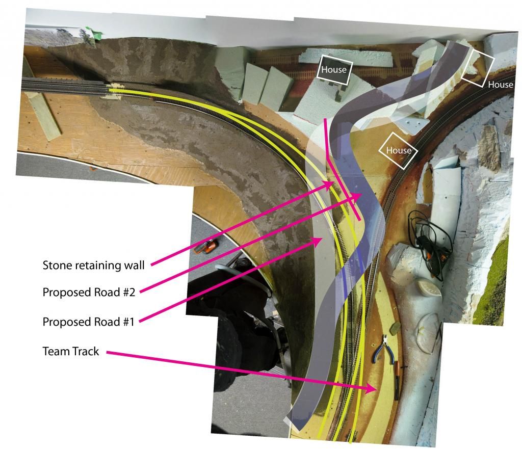
Proposed Road 1 follows the river, crosses the track near the turnout and gently climb the hill with a long curve.
Advantages: siding isn't obstructed by a road crossing, slope is gentle, realistic topography is possible, the road along the track is a nice addition and prototypical to some extent.
Disadvantages: access road to team track must crosses the siding in the middle, track hidden behind vegetation is only on a very short distance before the bridge.
Proposed Road 2 quickly leaves the river shore and crosses the tracks, then is turn left and right while climbing the road.
Advantages: the retaining wall is needed, the winding road makes the perspective more interesting, access road to team track is direct without needing to cross the siding, the track lost in the wood scene before the bridge is longer.
Disadvantages: the road crossing cuts the siding in 1/3-2/3, that means a cut of cars could obstruct the road for a long time, the slope could look toyish because of the many curves it could be hard to make the topography realistic.
At this point, both ideas have to be tried on the layout. I can't hardly say one is better than the other. Netherless, I think Proposed Road 2 is a strong contender. I'm eager to see how it will turn out in 3D. Anyway, I think this scene can hardly support more than 3 houses before looking cluttered.
*****
By the way, I was really disappointed this week to find out The Whistle Post vanished from the web. It was there we could admire the wonderful work of fellow australian modeller Mike Cawdrey. His artistic approach to New England in winter scenery is among the most inspiring out there. We can still see his work on the web, the lost of these archives and WIP explanations is not something you can replicate. Anyway, I'm still happy to have followed this thread over a few year. Mike is probably the guy that made me realize there was no shame in modelling a "modern" (eh, 80s were yesterday!) railroad. His creative approach to this hobby is another way to do model railroading.
No comments:
Post a Comment